Section 1: FAQs
What is a subject property?
What is a subject property?
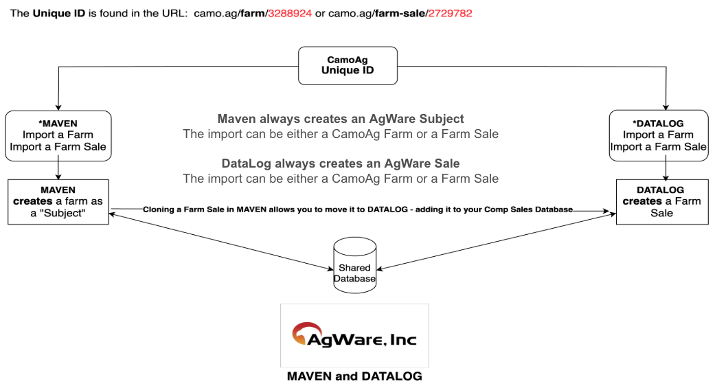
A subject property refers to a specific parcel or tract of agricultural land that is being evaluated or appraised. It is the primary focus of the appraisal process, where various data points such as ownership, land use, soil quality and other relevant characteristics are collected, analyzed and documented.Camoag simplifies the process of creating a subject farm/property with its comprehensive search capabilities, digital plat map and robust mapping tools. Once a subject farm/property is created it can be synced to AgWare Maven to complete the appraisal. You can read more about the Farm Import Process on AgWare’s website here.
Can I upload additional documents to a farm so that those documents get transferred into AgWare?
Can I upload additional documents to a farm so that those documents get transferred into AgWare?
Yes, you can upload documents, photos, maps from other sources to your subject farm.
Why should I use CamoAg to find my subject farm?
Why should I use CamoAg to find my subject farm?
When a subject is captured in CamoAg, by default, a number of attributes from public information associated with the property; State, County, S,T,R, Lat/Long, PIN, Crop History, Soils(type, class and capabilities), shapefile.
Can I determine additional attributes/data on import I would like to be populated in Agware?
Can I determine additional attributes/data on import I would like to be populated in Agware?
Yes, you can work with AgWare to define additional attributes to be auto-populated.
Can a subject property become a Comp?
Can a subject property become a Comp?
Yes
If I edit/update a subject farm in AgWare does it get updated in CamoAg?
If I edit/update a subject farm in AgWare does it get updated in CamoAg?
Yes
Who is the single source of truth for subject properties?
Who is the single source of truth for subject properties?
AgWare
Are updates from AgWare instantaneous in CamoAg or is it a scheduled update?
Are updates from AgWare instantaneous in CamoAg or is it a scheduled update?
They are extracted and moved daily.
Section 2: Workflow for Creating a Subject Farm
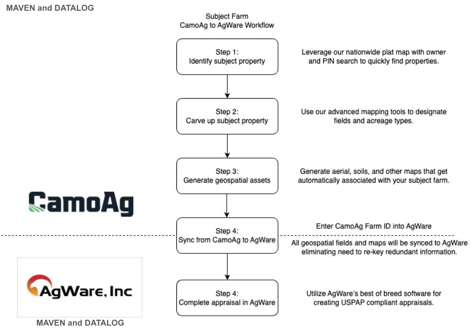
Section 3: How to Create a Subject Property
Guides are linked within each step| Step 1 | Step 2 |
|---|---|
| - Ways to search for your subject property - Browse the plat map and select parcel - Search by PIN/APN - Search by Owner - Search by Section, Township, Range - Enter Address - Enter Lat/Long - You can add multiple Parcels/Fields to your Subject - Optional way to add a property: Getting Started with the Deed Mapper | - A unique Farm ID is generated for your farm/subject (see below) - Map out your subject using CamoAg’s Mapping tools for seamless transition to AgWare with all your edits captured - Utilize 2008 CLU’s for field boundaries - Make edits to the fields or parcels using any of the following features: - Merge fields - Using the Cut Tool - Using the Draw Polygon Tool - Designate Acre Types of your subject - Dryland, Irrigated, CRP, WRP, Waste, Woodland |
| Step 3 | Step 4 |
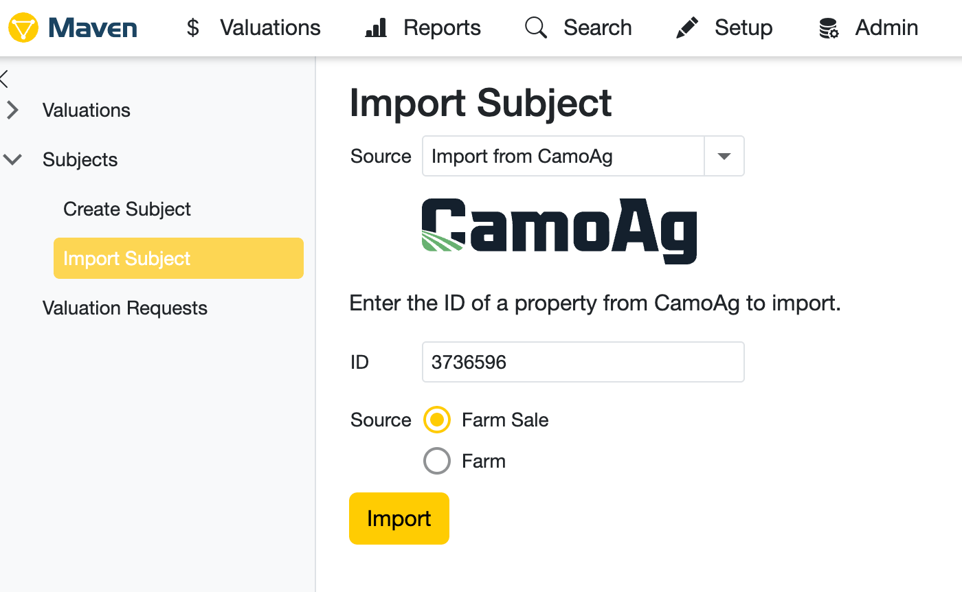
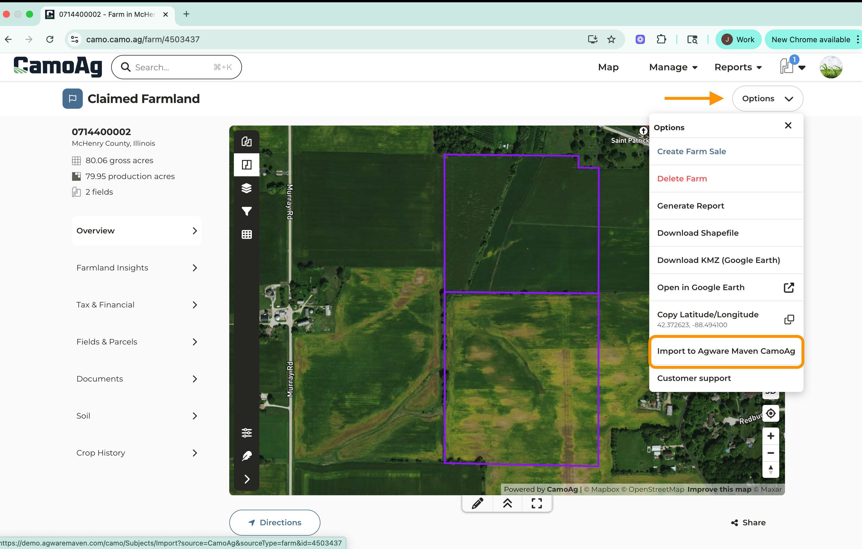
| - Add/Attach all relevant documentation to support your subject - Generate various pdf maps: soils, aerial, crop history, county yield - All maps get stored in Documents - Any additional pdf’s/supporting documents can be uploaded to Documents | - Import to AgWare/Maven from the Options menu of the subject property - Any/all documents attached to your subject property get seamlessly transferred into AgWare/Maven and stored as an Attachment Complete Appraisal in AgWare! |
Please note that CamoAg is unable to provide support for Maven/Agware. If you run into questions with the Maven/Agware platform, please reach out to their team. Questions specific to CamoAg should be sent to support@camo.ag